Galapagos, Ecuador

The birth place of Charles Darwin’s theory of evolution, the Galapagos archipelago is considered to be one of the most pristine ecosystems in the world. The 20 (13 major and 7 small) islands here boast amazing wildlife, making it a nature lover’s paradise. Interestingly, the Galapagos archipelago was once used as a prison camp. For a long period of time, the ecosystem was not properly cared for, resulting in depletion of natural resources. Today, there is a large effort to maintain the pristine condition of the islands and care for the many species that are native to the Galapagos. Officially part of Ecuador, the Galapagos straddle the equator off South America’s west coast. The islands were formed due to the Galapagos Hotspot and the shifting of earth’s tectonic plates. In fact, the youngest islands, Isabela and Fernandina, are still being formed through volcanic activity. Each island boasts unique sites, with luscious tropical forests covering some and barren volcanic rock making up others.

Kicker Rock in the Galapagos
Sunset on San Cristobal in the Galapagos

When to Visit the Galapagos Islands

Average temperatures in the Galapagos range from 69°F-84°F year round. The dry season in the Galapagos (July to December) is best for scuba diving and observing the mating rituals of the Blue Footed Boobies and the Genovesa Owls. In the dry season, daytime temperatures are usually no higher than 75 degrees Fahrenheit. The wet season, in the first half of the year (January to June), has rain daily, but is warmer (air temperature is in the low 90s and water temperatures in the high 70s or 80). Keep in mind that temperatures and rainfall fluctuate between the islands due to difference in elevation and wind patterns. Peak tourist seasons in the Galapagos is from June to September and December to January. Always book well in advance as the Galapagos National Park limits the number of tourists visiting at one time.

Sea Lion in the Galapagos

WHAT TO BRING TO THE GALAPAGOS ISLANDS

Travelers will need a variety of gear for this destination: swimsuit, towel, sunscreen, beach wear, followed by hiking boots, trekking pants, bug spray, and a light jacket. A pair of Teva or Chaco like sandals that can double as a beach as well as hiking shoe would also come in handy. Bring binoculars for bird watching (many exotic species here) and a camera, of course. There are plenty of places to rent snorkels, wet suits, and scuba gear in the Galapagos, so leave that at home. At the time of this post, there is a 20kg limit for checked luggage on the flight to the Galapagos.

HOW TO GET TO THE GALAPAGOS ISLANDS

There are two airports on the Galapagos Islands. The Seymour Airport on the Baltra Island (Airport Code: GPS) and the San Cristobal Airport (Airport Code: SCY) on San Cristobal Island. Direct flights to the Galapagos from Ecuador are offered from both Quito (Airport code: UIO) or Guayaquil (Airport code: GYE). There are three airlines that fly to the Galapagos Islands which are Tame, Avianca, and LAN. It is often more convenient to fly into San Cristobal and out of Baltra (or vice versa) as travelers typically do not stay on one island the entire time.

TRAVELING IN THE GALAPAGOS ISLANDS

In terms of traveling between the islands, travelers can either stay on one island and book day tours from these islands (Puerto Ayora on the island Santa Cruz is a popular hub), or book a cruise. Plan ahead, because the Galapagos National Park require visitors to be accompanied by a licensed guide. If you are hoping to see some of the more remote islands, a small cruise (duration anywhere from 3 to 10 days) is the way to go.

WHAT TO SEE IN THE GALAPAGOS ISLANDS

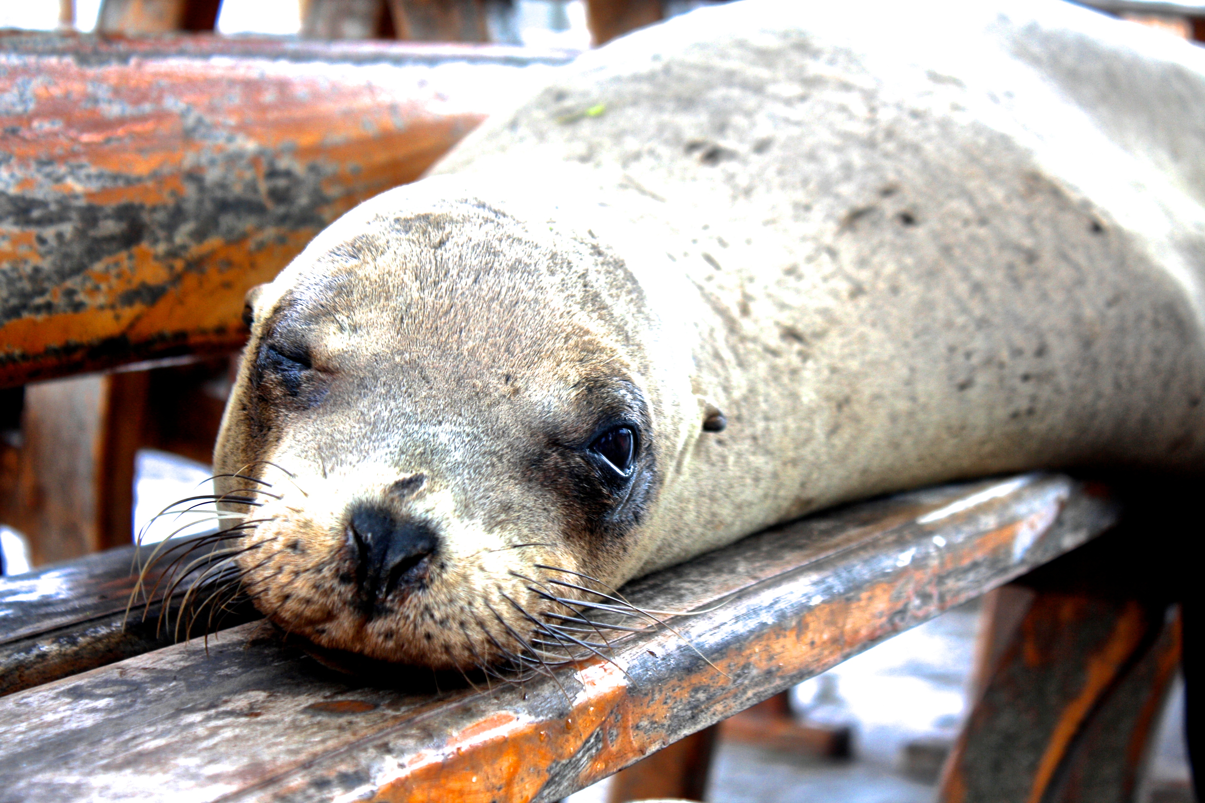
Kicker Rock (on San Cristobal Island) is a snorkeling site where travelers can see sea turtles, sharks, sea lions, octopus, and schools of fish. On the island of Santa Cruz be sure to visit Puerto Ayora, which is home to the Charles Darwin Research Station,  El Chato Tortoise Reserve (giant wild tortoises) and the Galapagos National Park. Tortuga Bay, a short walk from Puerto Ayora, has a great beach and wildlife that includes marine iguanas, birds, and mangroves. On the island of Española, visitors can see the mating rituals of the albatrosses as well as the mating dance of the blue-footed boobies. Santiago, or James Island, is home to a sea lion species (called the fur seal) that is endemic to the Galapagos, as well as sea turtles, and several coastal birds. In the Galapagos, or the Enchanted Islands as they are often called, travelers can see wildlife that is found nowhere else on earth.

Galapagos Ecuador crabGalapagos ecuador sea lions

Thanks to Alissa from Villanova University for sharing her great travel tips on the Galapagos Islands!

Cusco, Peru

Situated in the Peruvian Andes, Cusco, often spelled Cuzco, is a charming town of 350,000 and a UNESCO World Heritage Site. Often a stop for altitude acclimation before heading to Machu Picchu, Cusco itself has a lot to offer also. Built atop the ruins of the Capital of the Incan Empire from the 15th century, Cusco has a very rich history with its own Incan ruins-Sacsayhuaman and Qurikancha. The Historic District is full of beautiful churches and colonial style architecture. Outdoor enthusiasts will be amazed by the scenic trekking and beautiful sites, and the night owl can experience the local discotecas. The sky here is speckled with peaks from the Andean Mountain Range and you can appreciate this as you stroll through the city, visit the churches, shop in the markets, and meet travelers from around the world. In one day, I met a man from Scotland, a student from Hungary, and two women from Brazil. In your journey to Machu Picchu, be sure to leave a couple days (and at least one for altitude sickness) for Cusco!

Church of Santo Domingo in Cusco
Church of Santo Domingo in Cusco with the official flag of Cusco

The Best Time to Visit Cusco

The average temperature in Peru’s winter is 67.1°F, and there is an average temperature of 67°F in the summer months. The best time to visit Cusco is between June and September (summer), which are the driest months. However, a word of warning to travelers, because Cusco is such a popular tourist destination with millions of tourists flocking to the city every year to visit the nearby Machu Picchu, tourist season can get very crowded! Hostels and tourist attractions often raise their prices during peak season. If you are looking to avoid some of the crowds, travel in May or October, to have a better chance at dry weather and less crowds.

What to Bring to Cusco

Situated at 3,400 meters above sea level (11,000 feet), Cusco is not the typical tropical climate that many think of for a South American destination. Though daytime temperatures are mild year round in the mid to upper 60s, the nights can drop into the 30s-40s. Given the variability, layers are definitely the way to go! Excursions in Peru require light weight trekking pants, and light weight long sleeve shirts, which also helps to minimize the number of bug bites. Also, if you are planning on doing a trek to Machu Picchu, pack hiking boots, hiking gear, walking sticks (optional), and rain gear (plus a backpack cover). For travelers intending to trek to Machu Picchu, some hostels offer lockers to store unnecessary belongings while on the trail. It is not uncommon to have issues with altitude sickness, but luckily the abundance of products made with coco leaves (natural remedy for altitude sickness) are available at every corner. Travelers can also talk to their doctor about a prescription for acetazolamide for altitude sickness.

How to Get to Cusco

Direct flights to Cusco arrive mostly from Lima (airport code: LIM), Peru’s capital. The non-stop flight from Lima to Cuzco takes just under one hour. Alejandro Velasco Astete International Airport (airport code: CUZ) is a 10 minute drive from the historic center of Cusco. Cusco’s new airport, Chinchero International Airport, could open as early as the end of 2016. All flights will eventually be transferred to the new airport, but for now you are likely to fly into the older one. The only official taxi company is Llama Taxis, which has a booth in the baggage claim area. A ride into town will cost about 35 soles (12 USD).  When using a taxi in Cusco be sure to bargain the price before you go anywhere as taxis are not metered. The price should be anywhere between 10-15 soles (3-5 USD). Public transportation is dominated by local buses, known as Combis, which are .60 soles (0.25 USD), and there is a stop right outside the airport. Unless traveling on a really tight budget, take a taxi, as buses have been known to have pick pockets.

Top Tourist Sites in Cusco (Cuzco)

Machu Picchu, which is an UNESCO World Heritage Site and one of the Seven Wonders of the World, is the most popular destination for visitors in Cusco. These 15thcentury Incan civilization are 50 miles northwest of Cusco. Travelers can take a train or trek. The Incan Trail and the Salkantay Trail are two of the most popular trekking options. Prices for the 4 day trek on the Incan trail, which need to be booked months in advance, range 550-1000 USD. The Salkantay Trail (also book in advance) has slightly cheaper options. If you have time to spare and are not traveling in high season, you can try waiting until you get to Cusco to book a trek. We did this and bargained a rate of 250 USD for a 4 day trek. A great way to spend a day in Cusco is to take one of the free walking tours (tip your guide) around the city and then visit the San Pedro Market for Andean cuisine and shopping.

Cusco Salkantay Trail Trek
Salkantay Trail from Cusco to Machu Picchu
Salkantay Trail
Salkantay Trail
Thanks to Alissa from Villanova University for sharing her great travel tips on Cusco!

Old Town, Quito, Ecuador

Old Town Quito, nestled within the Andes Mountains, is full of winding side streets, beautiful churches, and delicious bakeries and cafes. El Centro Historico in Quito, as it is called locally, is one of Ecuador’s UNESCO World Heritage sites. Though formally founded in the 16th century, the history of Quito dates back to the Incan ruins that the city was built on. Spend time walking through the narrow streets of Quito, to gain a unique insight into Ecuador’s rich culture. The music from street performers can always be heard as you wander through the shops and churches throughout the city. On Sundays, the main streets are bustling with people heading to and from church, and the night life is dominated by vibrant salsa clubs and flavorful dining.

Quito Ecuador

Ecuador old town quito basilica of the national vow
Basilica of the National Vow

Ecuador old town quito church

HOW TO GET TO QUITO

Direct flights to Quito into Mariscal Sucre International Airport (Airport Code UIO) leave from New York City, Miami, Atlanta, Houston, Bogota, Mexico City, and Panama City, . Quito’s airport is located about 45 minutes east of the city of Quito and is one of the busiest airports in South America. There are several options for getting from the airport to the main part of the city. The Aeroservicios Express Bus (8 USD) runs to the old airport (which is in the city of Quito), where you can then catch a taxi within the city which typically run from 5-10 USD. If you have a lot of time and not a lot of luggage, you can also take a green bus (2 USD) which runs to the Rio Coca bus station in Quito. If you choose this option, be aware that it typically takes 2 hours of travel time and there is no designated place for luggage. If it is your first time to Ecuador, catching a cab is the easiest, and is typically a 25 USD fare.

WHAT TO BRING TO QUITO

The weather in Quito can be quite unpredictable, so bring clothes for sun, rain, hot and cold. Even though Quito is right near the equator, the high elevation keeps the city at a much milder temperature, and it can actually get quite chilly in the evening. Keep in mind that there is generally a higher chance of rain in the afternoons so make sure to bring an umbrella and raincoat even if it is sunny when you leave for the day! Make sure to pack plenty of pants and long sleeve shirts because, in Ecuador, shorts are not typically worn by either men or women. Pants and longer dresses are suggested for women.

WHEN TO VISIT ECUADOR

Quito, the capital of Ecuador, is just 20 miles from the equator. But due to its elevation over 9,000 feet (Quito is the highest capital city in the world),  the average temperature year round is in the mid-60s (Fahrenheit), and can drop down into the 50s at night. The main seasons are the short dry season (summer) which is from only June to September, followed by winter (the wet season) which lasts October through May. Be aware that the dry season can still have a few days of rainfall. Peak travel season is determined by holidays. If visiting during Christmas or Easter, keep an eye out for numerous processions and festivals in Quito.

QUITO’S BEST TOURIST SITES

While Ecuador is most famous for the galapagos, some of Ecuador’s best tourist sites are in Quito. Visit Quito’s numerous churches that have a range of architectural styles. For a great view of the city, climb up the spires at the Basilica of the National Vow and take in the scenery. El Panecillo in Old Town Quito is a giant statue of a winged Virgin Mary. The streets surrounding the statue are not the safest, so take a taxi here. The best place for night life in Quito is La Ronda-a street blocked off for pedestrian traffic only. This street is home to live music, street vendors, and great restaurants. In La Ronda, try Canelazo, a warm alcoholic drink, and the large cheese empanadas. Finally, to get the ultimate view of the city, visit El Teleferico-the world’s second highest cable car. El Teleferico climbs Pichincha Volcano on the eastern side of Quito. On clear days you can see many of the active volcanoes that speckle Ecuador’s landscape. A ride up the cable car is about 4 USD for locals and 8.50 USD for travelers.

*Traveler’s Note: The Zika virus was reported in Ecuador in January 2016. It is transmitted by mosquitoes and has been known to cause birth defects. Pregnant women, or women planning to become pregnant, should use caution when traveling to areas affected by the Zika virus.

Thanks to our Alissa from Villanova University for sharing her travel tips
Thanks to our Quito travel expert, Alissa, from Villanova University for sharing her travel recommendations!


Chile’s Largest Salt Flat

Nestled in the northern region of Chile is the desert town of San Pedro de Atacama. Located within the Atacama Desert, the driest non-polar area (little to no precipitation) in the world, this town is centered around visiting the famous Chilean salt flat (Salar de Atacama), the red rock formations, and the picturesque lagoons. Originally belonging to Bolivia, Chile claimed this territory during War of the Pacific, and the Salar de Atacama is the largest salt flat in Chile. It is located 34 miles (55 km) south of the town San Pedro de Atacama and is surrounded by the mountain ranges belonging to the Andes. The salt flat here is one of the largest in the world at 3,000 km2 or 1,200 sq mi (the largest being the Salar de Uyuni in neighboring Bolivia). The small town of San Pedro de Atacama is great base for exploring this region of northern Chile.

Chile San Pedro de Atacama Piedras Rojas

The landscape surrounding the Chilean Lagunas (lakes) or Lagunas Altiplanicas located in this region
Piedras rojas (red rocks) created by volcanic lava and ash
Piedras rojas (red rocks) created by volcanic lava and ash with a lagoon in the background
Flamencos in the Chilean salt flat or "Salar de Atacama"
Flamencos in the Chilean salt flat or “Salar de Atacama”

When to visit Chile

Remember that summer in Chile is opposite that of the Northern Hemisphere. In San Pedro de Atacama specifically, the weather is arid and warm for several months of the year. From late October to April, the highs are in the 70s (F) and lows in the high 50s. Upon arrival, allow yourself a day or two to acclimate to the altitude before heading on any strenuous hikes.

What to wear/bring to san pedro de atacama

Since the Atacama Desert is the driest place it is important to keep yourself well hydrated. Furthermore, this town sits at approximately 7,900 feet (or about 2,400 meters). At high altitudes, boiling water for at least three minutes is the best way to purify water. Bottled water is also an option. Loose, light clothing for the day is recommended but bring a sweater for the low temperatures at night. If you are prone to altitude sickness, coca leaves can be purchased from local vendors. Remember that drinking alcohol can make altitude sickness worse. Additionally, bring plenty of cash! San Pedro is known for running out of cash in their ATMs.

How to get to san pedro de atacama

Non-stop flights to Chile (Santiago Airport Code – SCL) are available from NYC and Atlanta.  Cheap flights to Chile can be obtained by choosing a one-stop option. From Santiago, fly to the El Loa Airport in Calama, which is about 60 miles (100km) away from San Pedro de Atacama. From there, take a van or taxi to San Pedro (schedule this ahead of time for ease on arrival). Travelers can also take an overnight bus from Santiago.

How to get around

Because San Pedro is such a touristy area I cannot stress the helpfulness of the travel agencies enough. Several local tour operators can arrange all the details of your visit. Compare prices at a few different agencies to ensure that you are getting a reasonable rate. To get to close by attractions and getting around town, renting a bike is a great option. Not only is it a cheap way to get around, it is a unique way to experience the landscape.

What Not to Miss in Chile

This area of Chile is famous for trekking, biking, archeological guides, astronomy tours, horseback riding, sand boarding and tours of the Lagunas. My friend and I biked to Valle de la Luna, home of the salt caverns and dunes where one can see gorgeous sunsets. The next day we went on a tour of the lagunas. During our tour of the lagunas, we experienced pastel backgrounds and striking mountain ranges. We also attended an incredible astronomy tour and workshop. As we stargazed, we learned about how to spot galaxies and their different formations. Additionally, the geysers here are a popular tourist attractions. Travelers can also spend time enjoying the hot springs in this region.  Don’t forget to visit Chiloe and Patagonia while in Chile.

Thanks to guest blogger Marley, a student at Drew University with a double major in International Relations and Spanish, who hopes to leave the world better than she found it.

Whales and Penguins in Chiloé

Off the coast of southern Chile is the magical Grand Island of Chiloé. It is one of 30 islands that make up the Chiloé archipelago in the Lakes Region of southern Chile. It is the first island travelers see while crossing the Chacao Channel by ferry. The island is well known for whale watching, penguins and for its palafitos, which are colorful wooden houses on stilts along the water’s edge. There are also more than 150 iconic wooden churches from the 18th and 19th centuries, several of which are UNESCO World Heritage sites.  Chiloé is 118 miles from north to south and 40 miles east to west and it’s picturesque landscape, biodiversity and rich culture will captivate any traveler.

The palafitos on the water

Due to the history of separation from the rest of Chile, Chiloé is known for having a strong sense of territorial pride. Although geographically close to the mainland, they have developed a unique culture as well as gastronomy. Additionally, the people of Chiloé are on a mission to preserve their marine resources, as well as their rain forest, which is one of the world’s few temperate rain forests. The Alfagura Project is a marine life conservation effort operated from northwest of Chiloé. Chilean whalers called blue whales “Alfaguara” and thus, the project aims to preserve the endangered blue whale species. Thanks to this project, there is a vast amount of knowledge regarding the blue whale population in this part of the world.

ferry ride to chiloe

When I went to Chiloé my experience was defined by delicious homegrown food, breathtaking views, and a unique integration into the culture of the people. I spent a day with a shepherd, visited a woman’s artesian co-op, and toured a site where penguins come to mate for the season. My many ecotourism excursions placed emphasis on promoting a healthy and loving relationship with the earth.

port at chiloe

When to Visit

Between December and April, travelers have the chance to see blue and humpback whales. February has the most temperate weather with the clearest skies. September through March is breeding season for the Magellanic and Humboldt penguins in Puñihuil. During Chile’s winter months (June-August) there is more rain and some national parks close due to muddy trails, so check on the websites before visiting.

Penguins in Chiloe
Penguins in Puñihuil

What to wear/bring

Through all of Chiloé’s diversity, the one constant is rain. You will likely experience some cloudy days, misty mornings, and light rain at least once during your stay. Bring a poncho/raincoat and sturdy hiking shoes to battle the mud and rain. Also, layers are extremely important, especially when visiting the beach, as the temperature can change drastically on the coast.

How to get to Chiloé

Non-stop flights to Chile (Santiago Airport Code – SCL) are available from NYC and Atlanta.  Cheap flights to Chile can be obtained by choosing a one stop option.  From Santiago, travelers can fly into Puerto Montt (PMC) and then take a bus to Chiloé , or rent a car to cross the Chacao Channel by ferry.  If you rent a car, the cost to cross using the ferry will be around $16. The ferry is pretty awesome because it is so beautiful and if you are lucky you will get to see some marine life! You can also take a bus directly from Santiago but this bus ride is around 15 hours. The city of Punta Arenas also offers bus service to Chiloé.

How to get around the Island of Chiloé

The best way to get navigate the different parts of Chiloé are through prearranged tours or renting a car/transportation for your time there. There is also local bus service that is frequent and inexpensive. However, if you were looking to stay the night I would recommend arranging transportation through your hotel or hostel as they often have various options at very good rates.

What not to miss in Chiloé:

The highlights of a visit to this island include whale watching, nature hikes, visiting the UNESCO World Heritage Churches, and cultural immersion.  The best place to see the palafitos is in Costanera, Castro.  Be sure to not miss the old growth forests in the Chiloé National Park and the penguins in Puñihuil.  This is a nature lovers paradise.

Thanks to guest blogger Marley, a student at Drew University with a double major in International Relations and Spanish, who hopes to leave the world better than she found it.

Perito Moreno Glacier, Patagonia

Located in the Los Glaciares National Park, the Perito Moreno Glacier is one of Argentina’s most beautiful natural attractions.  The massive glacier spans 250 km2 (97 sq mi) , and is 30 km (19 mi) in length.  It is one of 48 glaciers in Patagonia and the ice field here is the world’s third largest reserve of fresh water.  In stark contrast to 95 percent of Earth’s glaciers that are slowly disappearing, Perito Moreno continues to grow.  The glacier was named after the explorer Francisco Moreno.  Moreno is known for his role in defending the territory of Argentina in a border dispute with neighboring Chile.

perito moreno glacier

WHEN TO VISIT Patagonia:

Spring in the southern hemisphere begins in September and lasts through November.  December through February is the summer season in Patagonia.  Because the weather is mild during these months, be sure to make your spring and summer travel arrangements in advance.  These months are the best weather for hiking and sightseeing, and the largest crowds are seen in the months of January and February.  November combines the best of weather and is just before the influx of large crowds.  Be sure to arrive in El Calafate the night before the day you plan to tour Perito Moreno, as the majority of tours for the glacier leave early in the morning and require the entire day.

Perito Moreno glacier

WHAT TO WEAR while visiting Perito Moreno Glacier:

Remember to pack layers for this trip!  Patagonia can be subject to heavy winds especially as you travel further south.  Good hiking boots and waterproof gear are essential.  The sun here also can be very bright especially with the reflection off the ice, so don’t forget your sunglasses.

HOW TO GET TO Perito Moreno Glacier:

El Calafate is a small city in Argentina near the edge of the Southern Patagonian Ice Field in the province of Santa Cruz.  Non stop flights to El Calafate (Airport Code FTE) are available daily from Buenos Aires and take about 3 hours.  There are two airports in Buenos Aires: Aeroparque Jorge Newbery, located in the city (code: AEP) and Ezeiza, which is about 22 km outside the city (code: EZE).  Non stop flights to El Calafate are more often found from AEP.  Once you are in El Calafate, travelers can either book a tour to the glacier or take the bus.

WHAT NOT TO MISS while visiting Perito Moreno Glacier:

Viedma glacier, the largest glacier in Argentina, is also located in Los Glaciares National Park.  However, you must travel from El Calafate to El Chalten, which is about a 3 hour drive away.  For thrill seekers, Viedma is a great place for ice rappelling.  While it can be done as a day trip from El Calafate, staying overnight in El Chalten is a better option.

Thanks to Nitasha, our night scuba diving, ice rappelling, class 5 white water rafting, black diamond skiing, oh and doctor / thrill seeker for sharing her tips on Patagonia!
Thanks to Nitasha, a night scuba diving, ice rappelling, class 5 white water rafting, black diamond skiing, oh and doctor / thrill seeker for sharing her tips on Patagonia!

The walled city in Cartagena, Colombia

Cartagena, Colombia (named after Cartagena, Spain) is a quick 4.5 hour flight from New York City.   The best part of Cartagena is the colorful colonial

walled portion which was named a UNESCO World Heritage Site in 1984.  You can either walk or ride a bike on top of the walls around the city.  Stop by at Cafe Del Mar to watch the sunset.  Stay in one of the many 6 to 10 room boutique hotels where the architecture has been preserved on the outside but all the comforts of the modern world (wifi!!!) have been added on the inside.  Although it is on the Caribbean Coast of South America, the beaches near the city are a waste of time.  For beautiful beaches, take a day trip out to Rosario Islands (https://vacayhack.com/2015/09/05/pablo-escobar-was-here/).

Rosario Islands, Colombia

We took a lancha 1.5 hours from Cartagena to the Rosario Islands, an archipelago off the coast of Colombia.  Some of the islands are tiny and have just one house on them.  The largest

  in the archipelago is La Isla Grande.  You can take any boat (una lancha) out to the cluster of islands from Cartagena- but then find a local guide on La Isla Grande.  A speedboat can efficiently take you around the perimeter to get a close up view of the now empty and insanely vast vacation / party complex of drug lord Pablo Escobar.  Our guide, Marcelo, also took us to a nearby reef to snorkel 😎 with some really colorful fish.  This area was founded as a National Park in the late 1980’s to protect the beautiful coral reefs of this region.  This area offers some of the best snorkeling in the caribbean sea.  After a long day in the sun here, return to colorful Cartagena for dinner in the walled city.